


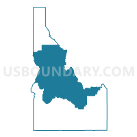
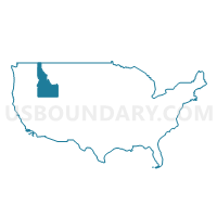
Central Idaho--Lewiston City & Nez Perce Reservation PUMA, Idaho
About
Outline
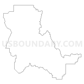
Summary
| Unique Area Identifier | 192772 |
| Name | Central Idaho--Lewiston City & Nez Perce Reservation PUMA |
| State | Idaho |
| Area (square miles) | 32,841.67 |
| Land Area (square miles) | 32,668.50 |
| Water Area (square miles) | 173.17 |
| % of Land Area | 99.47 |
| % of Water Area | 0.53 |
| Latitude of the Internal Point | 45.03503510 |
| Longtitude of the Internal Point | -114.82893800 |
Maps
Graphs
Select a template below for downloading or customizing gragh for Central Idaho--Lewiston City & Nez Perce Reservation PUMA, Idaho


Neighbors
Neighoring Public Use Microdata Area (by Name) Neighboring Public Use Microdata Area on the Map
- Ada (North), Payette, Canyon (North), Gem & Washington Counties--Eagle City PUMA, ID
- Ada County (South)--Boise (South) & Kuna Cities PUMA, ID
- Bingham (Outside Fort Hall AIR), Madison, Jefferson, Fremont & Teton Counties PUMA, ID
- Bonner, Latah, Shoshone, Boundary, Benewah & Kootenai (Southeast) Counties PUMA, ID
- Elmore, Jerome, Blaine, Minidoka, Gooding, Lincoln & Camas Counties PUMA, ID
- Southwest Montana--Butte-Silver Bow & Helena City PUMA, MT
- Umatilla, Union, Baker & Wallowa Counties PUMA, OR
- West Montana--Missoula City PUMA, MT
- Whitman, Asotin, Adams, Lincoln, Columbia & Garfield Counties PUMA, WA
Top 10 Neighboring County (by Population) Neighboring County on the Map
- Ada County, ID (392,365)
- Missoula County, MT (109,299)
- Bingham County, ID (45,607)
- Whitman County, WA (44,776)
- Ravalli County, MT (40,212)
- Nez Perce County, ID (39,265)
- Latah County, ID (37,244)
- Elmore County, ID (27,038)
- Jefferson County, ID (26,140)
- Asotin County, WA (21,623)
Top 10 Neighboring County Subdivision (by Population) Neighboring County Subdivision on the Map
- Lewiston CCD, Nez Perce County, ID (34,319)
- Eagle CCD, Ada County, ID (34,313)
- Mountain Home CCD, Elmore County, ID (24,241)
- Hamilton CCD, Ravalli County, MT (19,785)
- Orchard CCD, Ada County, ID (19,106)
- Clarkston CCD, Asotin County, WA (17,319)
- Lolo CCD, Missoula County, MT (14,611)
- Stevensville CCD, Ravalli County, MT (14,158)
- Hailey-Bellevue CCD, Blaine County, ID (13,714)
- McCall CCD, Valley County, ID (7,235)
Top 10 Neighboring Place (by Population) Neighboring Place on the Map
- Lewiston city, ID (31,894)
- Clarkston city, WA (7,229)
- Orofino city, ID (3,142)
- Grangeville city, ID (3,141)
- Salmon city, ID (3,112)
- McCall city, ID (2,991)
- Kamiah city, ID (1,295)
- Asotin city, WA (1,251)
- Robie Creek CDP, ID (1,162)
- Lapwai city, ID (1,137)
Top 10 Neighboring Elementary School District (by Population) Neighboring Elementary School District on the Map
- Stevensville Elementary School District, MT (6,625)
- Woodman Elementary School District, MT (451)
- Wisdom Elementary School District, MT (248)
- Jackson Elementary School District, MT (152)
- Grant Elementary School District, MT (142)
Top 10 Neighboring Secondary School District (by Population) Neighboring Secondary School District on the Map
- Missoula High School District, MT (100,417)
- Stevensville High School District, MT (9,662)
- Beaverhead County High School District, MT (8,738)
Top 10 Neighboring Unified School District (by Population) Neighboring Unified School District on the Map
- Boise City Independent School District 1, ID (184,995)
- Meridian Joint School District 2, ID (184,676)
- Lewiston Independent School District 340, ID (34,136)
- Mountain Home School District 193, ID (24,115)
- Blaine County School District 61, ID (21,376)
- Clarkston School District, WA (18,461)
- Emmett Independent School District 221, ID (16,719)
- Fremont County Joint School District 215, ID (12,140)
- Hamilton K-12 Schools, MT (11,122)
- Mountain View School District 244, ID (9,920)
Top 10 Neighboring State Legislative District Lower Chamber (by Population) Neighboring State Legislative District Lower Chamber on the Map
- State House District 9, WA (136,166)
- State House District 14, ID (76,940)
- State House District 21, ID (71,377)
- State House District 57, OR (57,718)
- State House District 60, OR (55,458)
- State House District 11, ID (51,062)
- State House District 34, ID (49,686)
- State House District 35, ID (43,409)
- State House District 25, ID (43,165)
- State House District 28, ID (41,905)
Top 10 Neighboring State Legislative District Upper Chamber (by Population) Neighboring State Legislative District Upper Chamber on the Map
- State Senate District 9, WA (136,166)
- State Senate District 29, OR (119,818)
- State Senate District 30, OR (115,913)
- State Senate District 14, ID (76,940)
- State Senate District 21, ID (71,377)
- State Senate District 11, ID (51,062)
- State Senate District 34, ID (49,686)
- State Senate District 35, ID (43,409)
- State Senate District 25, ID (43,165)
- State Senate District 28, ID (41,905)
Top 10 Neighboring 111th Congressional District (by Population) Neighboring 111th Congressional District on the Map
- Congressional District (at Large), MT (989,415)
- Congressional District 1, ID (841,930)
- Congressional District 2, OR (769,987)
- Congressional District 2, ID (725,652)
- Congressional District 5, WA (723,609)
Top 10 Neighboring Census Tract (by Population) Neighboring Census Tract on the Map
- Census Tract 9602, Blaine County, ID (9,878)
- Census Tract 102.01, Ada County, ID (9,390)
- Census Tract 9602, Elmore County, ID (8,923)
- Census Tract 9502, Boise County, ID (7,028)
- Census Tract 9602, Idaho County, ID (6,290)
- Census Tract 9503, Bingham County, ID (5,914)
- Census Tract 101, Ada County, ID (5,850)
- Census Tract 9400, Clearwater County, ID (5,721)
- Census Tract 5, Ravalli County, MT (5,561)
- Census Tract 9610, Nez Perce County, ID (5,347)
Top 10 Neighboring 5-Digit ZIP Code Tabulation Area (by Population) Neighboring 5-Digit ZIP Code Tabulation Area on the Map
- 83501, ID (34,230)
- 83221, ID (27,021)
- 83616, ID (22,780)
- 83702, ID (22,293)
- 83647, ID (20,789)
- 83714, ID (20,290)
- 99403, WA (19,548)
- 83617, ID (15,422)
- 83716, ID (14,523)
- 59840, MT (13,052)